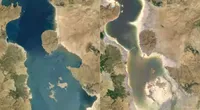
Google Earth Timelapse: Observing change

Observe how the earth has changed over the course of the last 35 years.

Lesson Overview

Observe how the world has changed over time
Google has access to a huge database of satellite imagery that goes back to 1984. It's made from over 15 million satellite images acquired by the USGS/NASA Landsat program and European Sentinel program.
Earth Timelapse is global zoomable tool that allows you to observe cloud-free change on the earth’s surface over the last 34 years.
- Introduction to timelapse
- Find a location
- Share your timelapse
- Timelapse video library
For more Environmental Journalism lessons, visit:
newsinitiative.withgoogle.com/training/course/environmental-journalism

Introduction to Timelapse


Accessing satellite data to show how the world has changed was once the realm of geographers. Earth Timelapse makes finding and sharing cloud-free satellite imagery as easy as point and click
Navigate to earthengine.google.com/timelapse/ Earth Timelapse combines over 15 million satellite images from five different satellites.The imagery comes from both NASA and European Space Agency datasets. The majority of the imagery is from Landsat, a joint United State’s Geographical Survey and NASA project, which has observed the Earth since the 1970s.
The left column has some examples that have been premade showing the tool’s capabilities. These include satellite imagery of:Bushfires in Australia;Coastal expansion in Dubai;Glacier retreat in Alaska;The arrow at the top will hide this panel.
The slider along the bottom shows the year that you are currently viewing. If you press play/pause the satellite imagery will scroll through with the year you are viewing highlighted in blue.
On the right of the slider you can control the speed of the playback.


Find a location


Find a location
The search bar on the top left is powered by Google Maps. You can search for any location in the world. When you click enter Timelapse will go directly to that location.
Click on the context map in the upper right to enter "Maps Mode."


Share your Timelapse

Once you have found an area of interest you can share or embed the view by clicking the share icon in the top left. You will be given the option of sharing a direct link to your view or an embed code that will allow you to place the timelapse into a story.

Use Timelapse videos

Timelapse video library contains over 300 4k pre-rendered videos that can be used in stories.
The videos can be searched for by
They are searchable by location and by theme, such as deforestation, mining, etc:

Congratulations!

You completed “Google Earth Timelapse: Observing change”
To continue building your digital journalism skills and work toward Google News Initiative certification, go to our Training Center website and take another lesson:
For more Environmental Journalism lessons, visit:
newsinitiative.withgoogle.com/training/course/environmental-journalism

-
-
-
影片:《專為記者打造的 Google 地球和地圖繪製技術》(Google Earth and mapping technologies for journalists)
課程探索記者如何運用 Google 地球和地圖繪製技術


